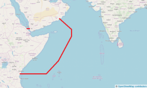
As announced on 22 August 2022 the Indian Ocean HRA for piracy removed on 01 January 2023. The related area that removed is the High-Risk Area as currently shown on UKHO Chart Q6099. The new coordinates of the HRA are:
From position A (Latitude of 01 30’S on the Somali coast), a line to 
Position B (01° 30’ S – 046° 00’ E), a line to
Position C (01° 00’ N – 049° 30’ E), a line to
Position D (09° 00’ N – 055° 00’ E), a line to
Position E (14° 20’ N – 057° 30’ E), a line to
Position F (the Yemen coast at longitude 053° 00’ E), then
Follow the Yemeni coast westwards and northwards, to
Position G (the Yemeni Red Sea coast at latitude 15° 00’ N), then a line to
Position H (the Eritrea territorial sea border at latitude 15° 00’ N), then
Follow southwards first Eritrea’s and then Djibouti’s territorial sea borders, to
Position I (the coastal border point between Djibouti and Somalia), then
Follow the Somali coast eastwards and then southwards, to Position A.
The removal of the HRA reflects a significantly improved piracy situation in the region. Voyage preparation, threat, and risk assessment as part of following Best Management Practice 5 (BMP5) remain essential.
Source: www.ukmto.org
Contact us to receive a professional advisory in your area of interest
